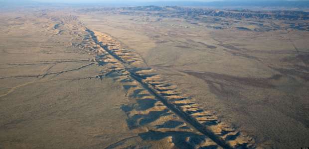
Some of the Western world’s major conurbations sit astride one of Earth’s most dangerous fault lines. Californian living along the San Andreas Fault are poised for a potentially devastating earthquake. A swathe that stretches from the coastline north of San Francisco south-east to the Gulf of California, and extends down into the Earth for about 10 miles (16km), marks the meeting point of two of the tectonic plates on which the continents and oceans sit.
These plates, with an average thickness of 60 miles (100km), are constantly in motion, drifting about on the fluid layer of the Earth’s inner mantle and jostling each other with enormous power as their positions shift and slide. And when they collide, the impact throws up huge mountain ranges, such as the Alps and the Himalayas. The circumstances that govern the San Andreas Fault, however, are quite different.
At first sight, the suburban streets of Taft in Central California look much like those of any other North American town. The broad avenues are lined with lamps house and gardens, cars are parked outside and the street lamps are sited at regular intervals. But something is amiss. A closer look reveals that the street lamps are not quite in line, and occasionally a whole street is kinked, as if its ends were being pulled in opposite directions. These of California’s major urban centres and a section of San Francisco’s Bay Area Rapid Transit System, is built along the San Andreas Fault, a fracture in the Earth’s crust that for 650 miles (1050km) of its length cuts through the United States mainland.
Here, the edges of the American plate (on which the greater part of the continent sits) and Pacific plate (which supports most of the California coastline) meet like badly aligned gears, neither colliding head on nor meshing smoothly. As the plates edge past one another, there is nowhere for the frictional energy that builds up along their margins to be released. Depending on the part of the fault in which this energy is generated, a small tremor or a major earthquake can result.
At so-called ‘creeping zones’, where the plates move past one another most easily, the energy that accumulates is dissipated in thousands of small tremors that cause little damage and can, in fact, only be detected by the most sensitive seismographic instruments. By contrast, some stretches of the fault seem completely immobile, fixed in ‘lock zones’, with the plates so tightly linked together that nothing moves in any direction for varying periods of time – sometimes hundreds of years. Under such pressure, great geological stresses build up until, eventually, the two plates force their way past each other in a violent release of pent-up energy. Earthquakes that measure at least 7 on the Richter scale, such as the 1906 devastation in San Francisco, are the usual outcome. (The Richter scale, named after the US geologist Charles Richter (1900-85), measure the intensity of earthquakes from 1 to 10: the smallest usually felt by human beings is 2, those assessed 5 upwards are potentially damaging).
Between these two zones are areas known as ‘intermediate zones’, where the activity, while not as devastating as that at lock zones, is still spectacular. The town of Parkfield, located between San Francisco and Los Angeles, sits above an intermediate zone, where earthquakes that may measure up to 6 on the Richter scale can be expected every 20-30 years; the last earthquake to hit Parkfield took place in 2004. A cycle of earthquakes happening regularly in a given area is unique to this region.
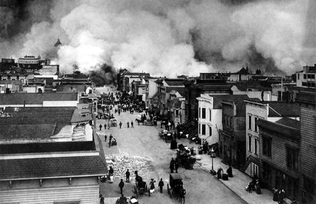
Geologists estimate that there have been 12 major earthquakes in California since AD 200, but it was the devastation of 1906 that drew the attention of the world to the San Andreas Fault. The earthquake was centred on the city of San Francisco itself and caused damage in an area that stretched for some 400 miles (640km) north-south. Along the line of the fault the ground shifted as much as 20ft (6m) in minutes – fences and trees were toppled and roads and pipelines broken (the resultant loss of water allowed the fire that followed the earthquake to rage unchecked through the city).
The future of San Francisco may ultimately depend on buildings designed to withstand earthquake shock and land movement. Many modern skyscrapers, including the pyramidal Transamerica Building, are strongly braced to increase stability. Similarly, bridges are now built with strips of metal embedded in their concrete, in an earthquake, the metal should buckle rather than snap, thereby reducing the impact.
A geological knowledge becomes more advanced and techniques become more sophisticated, measuring devices constantly monitor movements and water pressures beneath the Earth’s surface. Scientists believe that seismic activity shows slight increase for a number of years before a major earthquake, so it may be possible to predict future upheavals, and give hours or even days of notice. At the same time, architects and structural engineers are taking future tremors into account in their plans, designing buildings and bridges that are capable of withstanding a certain amount of movement of the Earth’s surface. As a result of this, the majority of the damage to buildings in he 1989 San Francisco earthquake occurred in old-style structures rather than modern skyscrapers.
The 1989 earthquake, which cost 63 lives, largely as a result o the collapse of a section of the double-decker Bay Bridge, was not the big-one’ that is expected to hit California sometime in the next 50 years. Estimates suggest that an earthquake measuring 7 on the Richter scale, and occurring in the Los Angeles region of southern California, could cause billions of dollars worth of damage and kill between 17,000 and 20,000 people, with fumes and fire affecting up to 11.5 million more. And, since the frictional energy that is built up along the fault line is cumulative, every year that passes before the earthquake occurs increases its likely magnitude.


