


From the Middle East to southern Africa a vast fissure is tearing apart the Earth’s crust. In the Great Rift Valley, remains of the earliest known ancestors of modern humans have been unearthed. The longest continuous cracks on the surface of the planet contains the lowest point on land and is flanked by some of the world’s highest volcanic mountains.
It holds several of the deepest lakes on Earth and provides a seaway between Europe and the Orient. The scar that Is the Great Rift Valley is of awesome proportions, measuring up to 60 miles (100km) across, and with walls falling to depths of between 1500 and 3300 ft (450 and 1000m) from the surrounding plateaus.
From Syria in the north to Mozambique in the south the Rift passes through 20 states and stretches 4200 miles (6750km) – almost one-fifth of the circumference of the globe. It is a spectacular example of what happens when two of the Earth’s crystal plates (one bearing the Arabian Peninsula and East Africa, the other the remainder of the African continent) shift and separate under land: constant pulling apart along the line of the Rift widens lakes and rivers and deepens gullies. In time, the sea may flood in, cutting off East Africa from the rest of the continent.
The term valley is a misnomer since the course of the Great Rift is invaded by mountains and plateau. Nor is it a single fissure. In southern Ethiopia, it splits into two branches before re-forming in the area of Lake Victoria on the Tanzania-Uganda border. The lakes, seas, and depressions that line its path, however, give the clearest indication of its progression.

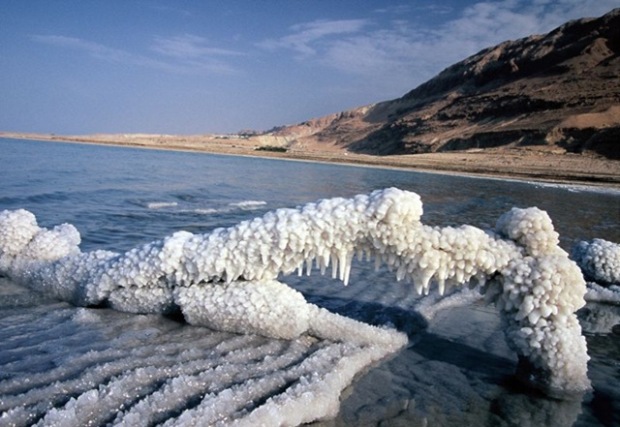
The Rift, starting in Syria, forms the valley of the River Jordan and the Dead Sea. The surface of the Dead Sea, at more than 1300ft (396m) below sea level, is the lowest point on all the continents. At such depths, the valley acts like a giant basin into which water flows, but from which it rarely drains. Instead, in the high temperatures of this region, rapid evaporation makes any large body of water such as a lake very salty. The salinity of the Dead Sea (some 30 per cent, almost ten times that of ocean water) enables bathers to float easily in its waters.
Around 500 miles (800km) from the Rift’s beginnings, ocean floods in, and the scar travels the length of the Gulf of Aqaba and the Red Sea before swinging south into the continent of Africa at the broad, fan-shaped Danakil (or Afar) Depression in Ethiopia. Salt waters akin to those of the Dead Sea once flooded this 2000 sq. mile (5000km) flat plain, some 510ft (155m) below sea level. But all the water evaporated, leaving behind deposits of rock salt that in places are 3 miles (5km) thick.
The Danakil Depression glistens with rock salt, an important commodity in an area where bodies lose their own salt fast, and where the infertile land makes growing crops impossible. Working in temperatures that often exceed 125°F (52°C), men use poles to pry chunks of salt away from the rock bed.

Of all the lakes that have been carved along the Rift, the freshwater ‘Great Lakes’ of East Africa – Tanganyika, Malawi (also known as Nyasa) and Victoria – offer a marvelous illustration of evolution in action. Just as the isolated continent of Australia has several unique species of animal, so the waters of these lakes, separated by vast expanses of dry, barren land, contain several hundred fish species that do not exist anywhere else in the world.
Lake Natron in Tanzania, stained red by the seasonal growth of algae, provides one of the most uncanny sights on Earth. Vast spirals of sodium carbonate, thrust up from the bowels of the Earth by geysers, bubble to the surface of the lake and crystallize into slabs of natron (a crystalline salt) that float across the waters of the lake like miniature icebergs.

Like Lake Natron, Lake Magadi in Kenya resembles a vast cauldron bubbling with soda and alive with algae. Only flamingoes can profit from these intensely alkaline waters, sieving them through their horny beaks for the teeming plant life that constitutes the major part of their diet.

Victoria, which at 280ft (85m) deep is the shallowest of the three lakes, is also the youngest, having existed for some 750,000 years. It was formed when land to its west rose, damming the course of several rivers. As each river expanded and deepened to form a small lake, in addition to the fish that already existed new species evolved by taking advantage of the different habitats on offer. Lake Victoria itself also changed, at times flooding to take in creatures from what had been isolated waters, at others drying out, returning species to seclusion. In the case of the narrow, deeper and much older lakes of Malawi and Tanganyika – over two million years old – it seems more likely that new species simply evolved from populations that became isolated because of their habits.
Since rift valleys occur above ‘hot spots’ in the Earth’s crust, where differences in temperature and density cause molten magma to rise towards the surface of the planet, volcanic activity along their length is common. So it is in East Africa, where several massive volcanoes dot the landscape. Mount Kilimanjaro (on the Kenya-Tanzania border) and Kenya (in Kenya), the highest peaks on the continent, sit along the line of the Rift. In northern Tanzania, the collapsed crater of a third volcanic summit, Ngorongoro, provides one of Africa’s premier wildlife sanctuaries. The Serengeti Plain to the west supports 100 times more animals than Ngorongoro. But since the crater benefits from a natural irrigation system and is almost never dry, it can provide water and grazing all year round. The 3 million animals that make their home on the Serengeti, by contrast, must migrate to fresh pastures in the dry season.
The rich grasslands of Ngorongoro Crater floor provide permanent pastures for 25,000-30,000 herbivorous animals. In addition to zebras and wildebeest, the crater also supports a small population of black rhino. It is thought that the abundance of shrubs, herbs and clover on which they feed more than outweighs the lack of the bush cover that they generally prefer.

Sandwiched between these two wildlife havens lies Olduvai Gorge, a cleft within a cleft that is around 330ft (100m) deep and nearly 30 miles (48km) long. Millions of years ago, as silt and sand drained from the seasonal lakes and streams that watered what was then the Serengeti plateau, they were laid down in the valley. Volcanic activity contributed lava and cinders to the layers of accumulated debris. Finally, when the land configuration changed yet again, the rushing waters of a new stream carved the gorge, the walls of which reveled not only strata of natural materials but also fossil bones and artefacts.

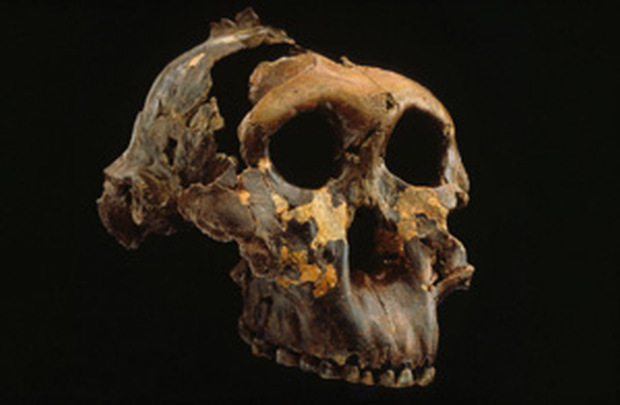
Owing largely to the work of Kenyan-born British archaeologist and anthropologist Louis Leakey (1903-72), his wife Mary and their son Richard, Olduvai has yielded fossil remains to fill vital portions of the rich tapestry human evolution. In 1959, the Leakeys came upon the first almost complete skull of a human-like creature of the genus Australopithecus (‘southern ape’), trapped between layers that can be precisely dated at 1.9 and 1.7 million years old. This hominid had a small cranium that enclosed a brain only one-third the size of that of a modern human, bu the shape of the base of his skull revealed he walked upright on two feet, rather than using his forelimbs for extra stability as do apes. There is also evidence of camp sites and tools of stone and bone. More than 50 hominid skulls have been uncovered at Olduvai, and other, even older, finds farther north in Ethiopia suggest that this part of Africa was the birthplace of the human species.
The Great Rift Valley is many things: cradle of humankind, wildlife sanctuary, and scenic wonder. But perhaps the most spectacular feature of the greatest crack on the Erath’s surface is that it is constantly rifting and spreading, as it does so, water invades more and more of the land. Eventually, the crack may become a tear, and East Africa will finally separate from the mainland, an island continent in a vast new ocean.
-end-


